
Skiing the Tödi
Starting the journey with our bikes in Lindthal
I had just come back from two days of skiing in the Jungfrau region when Georgia suggested another adventure: skiing the Tödi. Although my legs were still sore, I didn’t need much time for consideration before getting excited about the idea. After a rest day spent with very “active” recovery climbing on granite in the Schöllenen gorge near Andermatt, Georgia and I met on the train to Lindthal. From here, a road winds through a beautiful, pristine valley, blossoming with a sea of yellow dandelions at that time of year that contrast sharply against the crystal-clear blue sky. To avoid a potentially long (yet arguably scenic) hike along the road, we had brought our bikes. We followed the gradual uphill of the road all the way to Tierfehd at the valley's end. Starting an adventure by travelling as far as the paved roads will take you, only to continue on foot into the mountains, always feels particularly rewarding.
Initially, we believed our bikes were only good for reaching Tierfehd. However, when we stopped to stash them there, two middle-aged women expressed interest in our skis attached to the bikes and asked about our plans. Upon learning our intentions, they suggested we take our bikes further, explaining that the hiking trail leading to Fridolinshütte follows a well-paved gravel road for a considerable distance, likely making the bike approach even more effective. As we began the climb, we had to quickly dismount our bikes, however, as the incline became incredibly steep; even pushing them soon turned into a challenging and exhausting task. Georgia, in particular, burdened by her heavy mountain bike, soon began to doubt the validity of the advice we’d been given. Perhaps the heavy-duty e-bikes the women rode should have hinted that this road wasn't particularly suitable for human-powered biking?
Enjoying some flatter parts of the gravel road
We had to squeeze through a small construction site
Crossing a “bridge”
However, a quick check of the map convinced me these steep sections of the road were limited to its beginning, and I persuaded Georgia to continue pushing our bikes. Sure enough, the road’s gradient soon eased, and we were able to mount our bikes again. There were even a few hundred metres of flat terrain where we could make up for some time lost while pushing the bikes. We cycled through a short, damp tunnel that opened onto a bridge spanning a vast gorge, where a river roared at least a hundred metres below. After that, we encountered the only other individuals on the trail to the Fridolinshütte that day. They weren’t ski-tourers or hikers, but construction workers using heavy machinery to repair sections of the gravel road. With no alternative, we carefully pushed our bikes through the construction site, but the workers were understanding enough. Up until now, the path had been following a narrow valley, flanked by towering limestone cliffs rising several hundred metres to our left, but now the scenery began to feel less constrictive.
We left the forest we had been cycling through and could, for the first time, lay our eyes on the snowcapped summit of the Tödi. Though hidden behind some clouds, it towered over the surrounding mountains, framed on either side by the steep rock faces beneath which we had cycled. The landscape here had a peculiar feeling. Large patches of grass were still brown from autumn, having only just been revealed beneath the winter’s snow cover. While it might have felt like autumn because of that, many of the trees still exhibited no leaves and appeared desolate, as if they were still recovering from winter. There was a strange dissonance between this barren-looking landscape and the sense of rebirth and spring already in the air. We followed the gravel road to its very end, where it led to a water reservoir, explaining the existence of such a well-maintained piece of remote infrastructure in the first place. We stashed our bikes and enjoyed a brief lunch. When we attempted to mount the skis from the bikes to our backpacks, we experienced a moment of panic. Georgia’s bindings seemed to malfunction, but fortunately, they were merely jammed, and eventually, with some brute force, snapped back into their proper position. We laughed at this minor technical error, which had momentarily appeared to jeopardise our entire mission, unaware that this was only the beginning of the technical complications we would encounter on this ski tour…
Enjoying some more open scenery and the exceptionally well-maintained gravel road
Switching from bikes to feet
We set off onto the hiking trail, on foot at last. In the flat, open meadow beside the water reservoir, we witnessed a group of marmots playfully celebrating the arrival of spring. They were wallowing in the lush grass and wrestling with one another, appearing as if they had emerged from their burrows just moments ago and were discovering the world for the first time. Leaving this delightful scene behind, Georgia and I hiked up a steep, muddy path that ultimately led to an open, amphitheatre-like expanse enclosed on all but one side by steep and imposing limestone cliffs. Here, we encountered the first patches of snow. Unsure whether a suitable line for skinning existed, we remained on foot, navigating between the soft, mushy snow patches. We then examined the map for an extended period, trying to ascertain if following the ski-touring route was at all feasible under these conditions. Eventually, we resolved to forgo the snow and hike up a steep grassy hillside, which would likely lead us to the summer route towards the hut. The slope didn’t look too steep and was expected to be a shortcut, allowing us to avoid the steep, unstable snow slopes. It turned out to be a short but intense exercise with our heavy, ski-burdened backpacks. Once we reached the hilltop, we were rewarded with a view of the boundaries of continuous snow cover. Here, an obvious and easy enough skin track presented itself, which brought us to the hut within half an hour.
Upon our arrival at the hut, we were greeted by the dry humour of the hut guardian: “You’re twelve minutes early for dinner," she snarked at us. The journey had indeed taken longer than we had expected, totalling 4.5 hours. But while pushing our bikes slowed us on the uphill, it promised to save our legs the following day on the descent into Lindthal, which were sure to be tired after a long ski tour. The hut itself was a cosy little place, yet it felt nearly deserted at that moment. Besides us, there were only two other guests: a German duo of ski tourers who shared our dinner table. We learned they had travelled from Planurahütte and intended to descend to the valley via Urnderboden the following day. This meant Georgia and I would be the only ones attempting the Tödi the next day. After dinner, we spent some time browsing the hut’s library, diving into the history of this place, which is known as the birthplace of the Swiss Alpine Club. Its first hut was constructed just 400 metres from the Fridolinshütte at the base of the Grüehoren in 1863. The building now serves as a museum, and we would pass beneath it the next day. We then settled into our room, which we had entirely to ourselves, prompting another ironic remark from the guardian to keep the noise down, who evidently believed Georgia and I were a couple.
Getting close to the snow
Heading up the near-vertical grassy slope we chose in favour of the steep snow
The imposing limestone cliffs on the approach to the Fridolinshütte

Finally putting the skis to use for the last 200 metres
Reaching the Fridolinshütte
Some dubious weather rolling in during the evening…

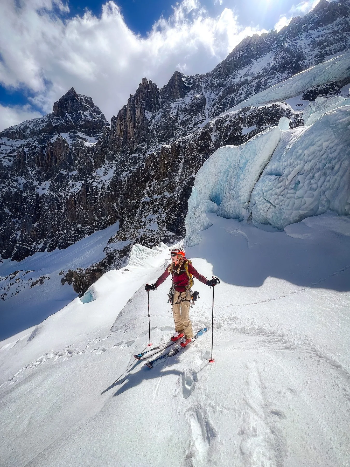
At the bottom of the glacier
“Georgia, this is kind of a problem!” I said, not yet fully wanting to believe what those words meant. We had risen to our alarms at 4:15 and were ready to step outside into a surprisingly warm night shortly after 5 a.m. The previous evening, we had learned there was only one route down to the glacier, which still had ample snow for skiing. We had started the brief walk toward this ravine on foot (though in hindsight, putting on the skins would probably have been more efficient) and then embarked on a harrowing ski descent over chopped-up, refrozen icy snow where our skis jittered uncontrollably at every turn – it was a true ordeal. For the last few metres, I had chosen to carry my skis and hiked down a steep slope through mud and gravel, at one point sinking to my ankles in the sludgy ooze. What should have been a simple 20-minute descent from the hut to the glacier had ended up taking us over an hour.
Starting the uphill
Now we were finally both standing at the bottom of the glacier, but our problems didn’t seem to end there. Georgia was struggling with her skins, which weren’t adhering to her skis at all; it was almost as if the glue had completely evaporated overnight. Georgia tried repeatedly to warm them, but to no avail; they still refused to stick. “Do you think we have to turn around?” I asked rhetorically. Georgia gave me a look of defeat and exasperation. However, neither of us was willing to accept that such a technical issue would force us to abandon our summit attempt before we had even done a single metre uphill. So, it was time to improvise with some ski straps. The contraption looked rather cumbersome, and Georgia would have to deal with some extra resistance on the skin track, but at least we could now make upward progress. We made our way across the frozen snow to a large boulder where we stashed our approach shoes. While waiting for Georgia to repack her backpack, I clumsily dropped one of my ski poles, which slid across the hard snow until it reached the bottom of the glacier, a hundred metres below. In this way, I earned myself some extra mileage retrieving the pole, and by now, we had already lost so much time that I was more than sceptical about our chances of reaching the summit that day. Nevertheless, we would attempt to see how far we could get.
Me going down the glacier to retrieve my lost skipole (photo credit Georgia)
Looking at the the second icefall (the red line showing our approximate route through the maze of sercas)
However, any hope for quick progress was abruptly halted when we discovered how difficult the next section of skinning was. The route starts by hugging the edge of the glacier to navigate around its first icefall. This stretch featured the steepest slope of the entire route, and it was still firmly frozen at this hour; an absolute nightmare for skinning. We threaded our way between old ski tracks and eventually got our ski crampons out, only to realise just moments later that even these were of little help. Consequently, we had to switch to bootpacking. Initially, Georgia was able to kick some decent steps into the snow, but after I took my turn breaking the trail, the frozen surface weakened, and I began sinking to my knees with each step. The next hundred vertical metres demanded some gruelling trail-breaking, and by the time the slope finally eased enough for us to use our skis again, we had lost even more time. Thankfully, however, the terrain ahead was easier to navigate, and with a surge of motivation, we soon found ourselves beneath the second icefall.
Entering the icefall
Navigating this piece of glacial architecture typically constitutes the crux of the entire route, and finding a way through this labyrinth of seracs can, at times, prove to be not entirely trivial. It was a daunting appearance at first. Immense blocks of ice were stacked atop one another, some rising several stories high. Encountering a dead end here would be rather unpleasant. However, beneath a thin layer of fresh snow, we could discern some wiggling ski tracks descending from a slope leading toward a potential entrance into this maze of ice and snow. This instilled confidence that we would find a way out on the other side by following these tracks. But once we left the slope beneath the icefall and reached the first seracs, the tracks all but vanished under the fresh snow. Now, we could only trust that following the most obvious path of least resistance would guide us through the intricacies of this ice. We secured the skis to our backpacks, and I quickly put on my crampons before taking the first steps into the uncharted territory. It was a bewildering feeling at first, venturing into such a staggering and ghastly environment, especially without any traces to follow, and with every step, I was penetrating deeper into an untouched world. However, I quickly grew accustomed to this feeling and soon came to appreciate the icy beauty of our surroundings. The initial feeling of trepidation gave way to a sense of wonder and astonishment at these elegant structures.
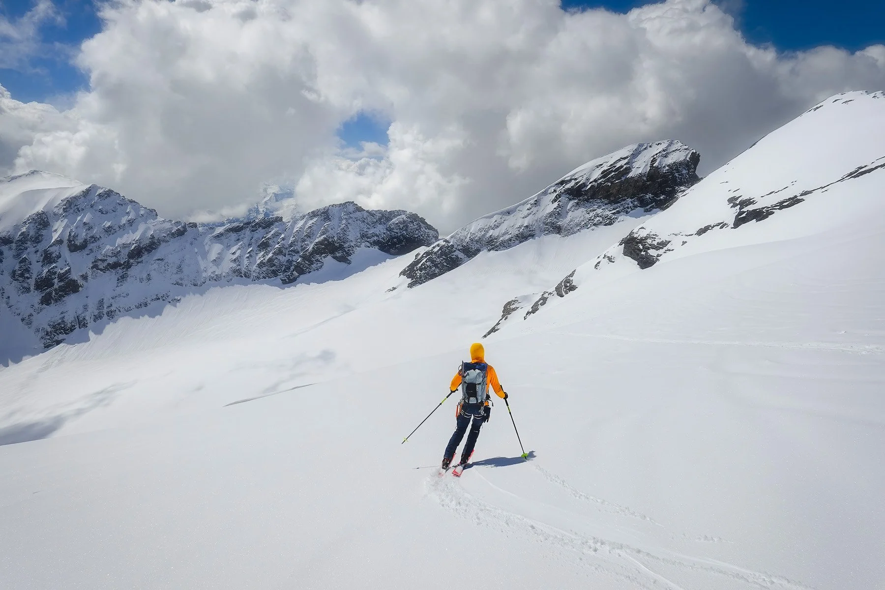
We made our way through this frozen labyrinth without any difficulties and emerged from the icefall just as the sun began to rise over the peaks of the surrounding mountains, warming our faces. It felt like emerging from a deep, tranquil ocean and inhaling fresh air for the first time. We felt a sudden rush of motivation; we had effortlessly navigated through the icefall, and now the only thing that stood between us and the summit of the Tödi was approximately 900 metres of uphill across a gentle glacier. The sun invigorated us with additional energy, and we decided to press on and see if the summit was not as unattainable as we had feared that morning.
Bootpacking the steep frozen snow in the morning (photo credit Georgia)
Approaching the icfall (photo credit Georgia)
Bootpacking in the icefall

Exiting the icefall and catching the first rays of sunshine
On the summit ridge with the summit cross in sight!
We were making good progress as we moved through the open expanse of the upper regions of the Bifertengletscher. For some time, we had observed a wall of clouds forming in the distance, but they were still far enough away not to cause any alarm. After passing below some hanging seracs at a safe distance, we rounded a corner and were now looking at the final stretch of our journey. I didn’t allow myself to fully believe in our summit success yet, but the inconspicuous-looking summit plateau of the Tödi was already visible in the distance, with only one last challenge remaining: a steep but short slope leading to the straightforward summit ridge. As we climbed this final ascent, Georgia suddenly exclaimed, “Look behind you!” I scanned the glacier below for a few moments and quickly spotted a dark shape moving in the distance. It seemed we weren’t as alone as we had thought.
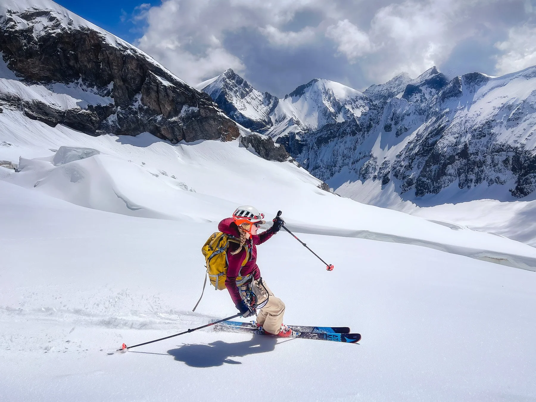
The final metres along the summit ridge were sheer joy, and I savoured every step, aware that we had actually succeeded against the seemingly insurmountable odds of the day. Georgia led us towards the heavy, sturdy summit cross of the Tödi. She struck a pose for pictures, one of her skins hanging half-heartedly in the air, with large clumps of snow accumulated underneath. I realised what an impressive effort it must have taken to drag this setup nearly 1700 vertical metres uphill, while the increasingly thin air surely didn’t make things any easier. Suddenly, I was even more astounded that we were actually standing here, with nowhere higher to go.
Georgia on the summit of the Tödi – only half of her skin still attached to her ski
Just moments after we took the obligatory summit selfie, the lone skier we spotted earlier reached the summit. He was clearly moving at an impressive pace, and after a brief chat, he revealed he had ascended all the way from Tierfehd that day in just 5,5 hours! As swiftly as he had arrived, he was off again, now seeking a suitable spot to take off with his paraglider. Anyone capable of covering 3,000 metres of elevation in under six hours clearly doesn’t concern himself with the boring and tedious descent mode that is skiing. We, on the other hand, were more than excited by that prospect. Ahead of us lay nothing but downhill terrain, and after watching the paraglider take off, we hurriedly stepped into our skis. The advancing wall of looming clouds also encouraged us not to linger any longer, so we were all focused on the descent ahead. And what a descent it was!
Our timing proved to be perfect, and the sun had transformed the top few centimetres of the snow into a delightful mix of fresh snow and slush. It was an absolute joy to ski, and on the gentle upper slopes of the Bifertengletscher, we could cruise almost without thought. Skiing across the glacier, with seracs and icy pinnacles framing our “piste” on either side, we revelled in the joy of a successful summit and the reward of a world-class ski descent. Plus thanks to the paraglider opting for air over snow, we had the slopes all to ourselves. I couldn’t understand why someone would choose to miss out on these joyful turns, but that was his loss. We had to steer clear of a few noticeable crevasses, but by following our skin track, we safely navigated back to the second icefall. We quickly shifted gears for a moment, remaining alert and focused as we made our way between the seracs. We could follow our fresh tracks from that morning, and in the end, skiing the icefall was not as stressful as we had feared. The snow was grippy, and everything was well snowed-in, so our skis never touched any ice. However, as we would soon find out, the real challenge of the ski descent was still ahead.


Looking back, the clouds started to engulf the glacier just as we had exited from its final slopes
We now left the sunlight and skied into the shadows cast by the surrounding mountains, which had kept the snow firm on these aspects. In fact, when we reached the first steep slope we’d bootpacked earlier, the surface felt even more frozen than it had this morning. We carefully made our way down, but eventually the snow became nearly as hard as ice. At one point, I almost lost my ski edges, which would have sent me sliding uncontrollably down to the glacier's base. Fortunately, I managed to keep control, and we both continued cautiously down this treacherous slope. Once we reached the bottom of the glacier, the only question was how to return to the hiking trail. We couldn’t ski the route we had ascended the day before, but numerous old ski tracks helped guide us across slopes strewn with avalanche debris and massive chunks of ice. Thankfully, the slopes above appeared to have already shed all but the snow they could hold. Still, we didn’t want to linger in such terrain, so we quickly manoeuvred between patches of snow and a few gravel gullies. After several more crunchy turns through slushy snow mixed with occasional pieces of gravel, we arrived at the open plateau where we had climbed the steep grassy slope yesterday.
The final turns between rocks, gravel, and avalanche debris
Switching into hiking mode
Approaching the end of the snow
Starting our blazing descent down the gravel road
Crusing down the tarmac into Lindthal
We were now able to enjoy some more sunshine as we took our time switching from our ski outfits into hiking clothes. Our backpacks, strapped with skis, felt oddly heavier than the previous day, but we knew it was only a short hike until we reached our stashed bikes. With the objective dangers behind us, we could fully relax and savour the feeling that comes with a successful summit. After a brief descent on foot, we found our bikes still safely tucked away where we had hidden them. Remembering the steep inclines we had climbed the day before, I suddenly felt a bit apprehensive. Taking a fall on the steep gravel wouldn’t be a pleasant conclusion to this trip, and it would be somewhat ironic if the bike approach turned out to be my nemesis. The descent was swift, yet I took my time, carefully operating the brakes of my bike as I made my way down. Georgia waited patiently for me at the bottom of the steepest sections, and ultimately, I didn’t need to dismount and successfully descended even the steepest parts of the road. We briefly stop at what can only be described as a natural whirlpool. Here, the river next to the road swirled around smooth rocks, forming a vortex of turquoise waters. I had made a mental note of that spot on the way up and couldn’t resist the opportunity for some skinny dipping in this oasis. The water was predictably icy, but after the initial shock, my body adjusted to the chill, transforming the pain of the cold into a somewhat pleasant sensation.
When we left the gravel road at Tierfehd, it had been under four hours since we had reached the summit of the Tödi, over 3,000 vertical metres higher. We cruised down the paved road into Lindthal, where we stocked up on snacks at the local grocery store, which we stuffed ourselves with while waiting for our train. We were both elated, coming back from such a long and successful tour after the summit had seemed so unlikely this morning. It made our success taste even sweeter. Now it was only after 4 p.m., and we would reach Zurich before dinner. One could grow accustomed to this efficient downhill travel in the mountains, although the paraglider surely still outpaced us by a couple of hours. However, he also missed out on the incredible natural jacuzzi, so I don’t believe he got the better end of that deal after all.